


(Reading the disclaimer before use is suggested)
(E)F5 Cases: 3.2% | (E)F4 Cases: 19.3% | (E)F3 Cases: 19.3%
Welcome!
This page acts as a library of model reanalysis vertical profiles (soundings) that represent near-storm environments of notable Michigan tornado and significant hail events from 1943-present using RAP/RUC (UCAR) & ERA-5 (ECMWF) model reanalysis data. This archive is meant to act as a reference and forecasting aid for CMU student forecasters for pattern recognition of tornadic & large hail environments in Michigan.
Total cases in archive: 64 | Dates: 1943-2024
TORNADO CASES BY DECADE:
– 1940s –
May 31, 1943 | Coopersville F2
Coopersville, MI
May 31, 1943 | 10:30 PM ET
F2 | 8.3mi | 300yd | UND
A single damaging EF-2 tornado, part of a multi-day severe weather event. The tornado was rated an F2, tracking 8.3 miles with up to 300-yard width. It damaged a few houses and carried clothes up to a half mile from one of the houses.

Jun 01, 1943 | Perry – Morrice MI F4
Perry → Morrice, MI
June 1, 1943 | 9:00 PM ET
F4 | 17.6mi | 400yd | UND
A large F4 tornado that destroyed over 250 buildings including 39 homes. Thousands of chickens were killed. Some buildings were swept from their foundations.

Jun 17, 1946 | Metro Detroit – Windsor F4
Metro Detroit, MI → Windsor ON
June 17, 1946 | 6:55 PM ET
F4 | 17.4mi | 200yd | UND
A violent tornado that caused around a million dollars worth of high-end-F3 damages in south Detroit, injuring 35 people. The tornado then crossed into Ontario, killing 18 people and producing widespread F4 damage. In total, 200 people were injured.

Sep 24, 1946 | Escanaba F2
Escanaba, MI
September 24, 1946 | 1:45 PM ET
F2 | 3mi | 200yr | UND
One home and $300,000 worth of damage to coal-loading equipment and coal docks were caused by this late-season F2 tornado.

– 1950s –
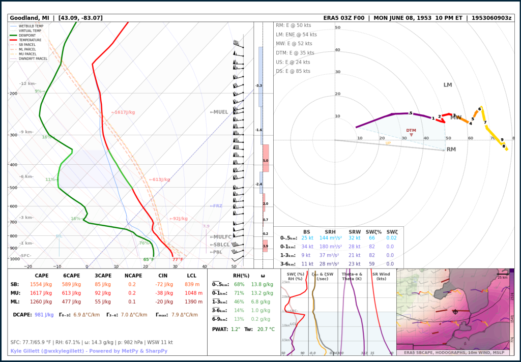
Jun 08, 1953 | The Great Flint-Beecher F5 (10th Deadliest Tornado in US history)
Flint-Beecher, MI
June 9, 1953 | 9:30 PM ET
F5 | 18.9mi | 833yd | UND
Currently the 10th deadliest tornado in US history, the Flint-Beecher F5 is Michigan’s ‘monster’ of years past. This tornado produced a half-mile-wide path of extreme damage in north Flint, killing 115 and injuring 844 people. Nearly all homes in the path were a complete loss. Caused $19,000,000 in damages.

Jun 08, 1953 | Lapeer and St. Clair Counties F4
Kings Mill → North Lakeport, MI
June 9, 1953 | 11:30 PM ET
F4 | 33.8mi | 830yd | UND
Parented by the same storm that caused the Flint-Beecher F5, this second violent tornado would be rated F4, killing 1 and injuring 34. Numerous barns were completely lost and several houses were damaged.
Apr 03, 1956 | Grand Rapids Long Track F5 (Michigan’s Most Recent (E)F5)
Zeeland → Grand Rapids → Trufant, MI
April 3, 1956 | 6:40 PM ET
F5 | 58.8mi | 400yd | UND
Michigan’s most recent (E)F-5-rated tornado killing 18 and injuring 340. This tornado devastated Hudsonville, Standale, and Comstock Park. Over $10,000,000 in damages would be reported. Some homes and businesses were completely lost.

Apr 03, 1956 | Lake Michigan to Grand Traverse Bay Long Track F4
Onekama → Bingham, MI
April 3, 1956 | 7:35 PM ET
F4 | 50.3mi | 400yd | UND
Either a single strong long-track tornado or a family of several strong tornadoes, suspected to have first started over Lake Michigan, tracking through sparsely populated north-western lower Michigan and ending over water just as it had started, in the Grand Traverse Bay. 2 were killed and 340 were injured. Several barns and homes were damaged or destroyed.

May 12, 1956 | Flint & Burton F4
Flint → Burton, MI
May 12, 1956 | 7:25 PM ET
F4 | 6.6mi | 100yd | UND
A violent tornado that destroyed 5 commercial buildings, 71 homes, and 70 other buildings in southeast Flint near Dort Highway. 284 other homes were damaged. 3 were killed and 116 were injured. The tornado produced $4,000,000 in damages

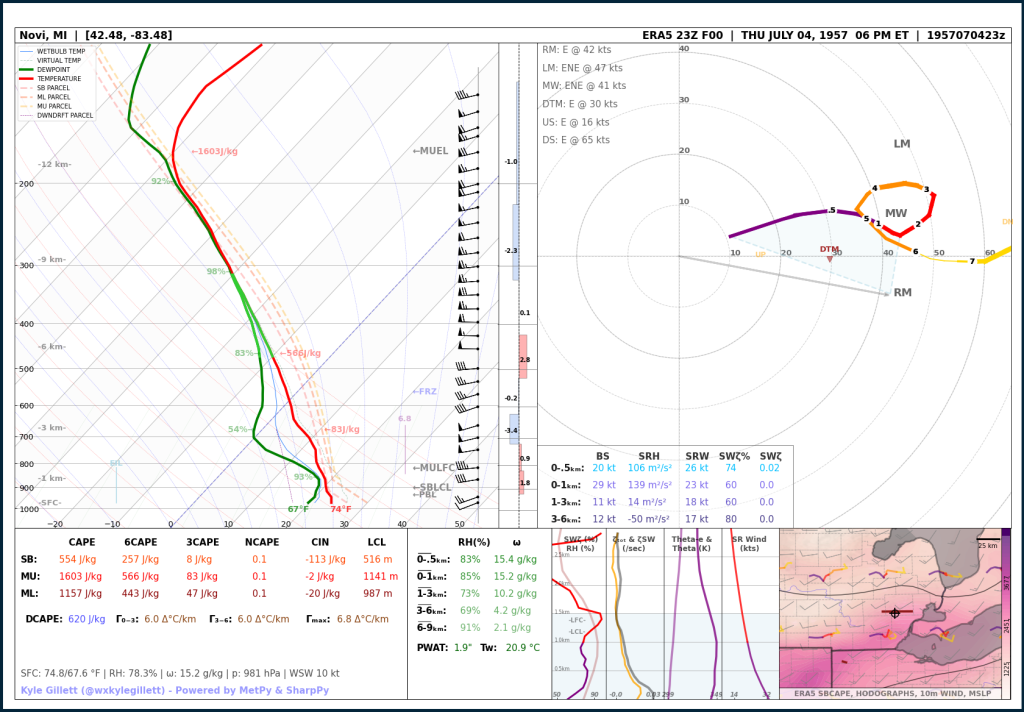
Jul 04, 1957 | Independence Day Oakland County F4
Brighton, MI
July 4, 1957 | 7:55 PM ET
F4 | 10mi | 100yd | UND
Two homes were completely leveled and 10 other homes sustained damage near Brighton by the first tornado, the F4. A Second tornado, rated F1, touched down around 30 miles away producing minor damage. 5 injuries were reported.
– 1960s –
Sep 22, 1961 | Ottawa & Kent Counties F2
Marne → Fruit Ridge Center, MI
September 22, 1961 | 6:22 PM ET
F2 | 2.7mi | 2000yd | UND
Three concrete buildings were leveled and several other buildings were damaged near Marne. 1 person was injured.

Apr 11, 1965 | Grand Rapids F4 – Palm Sunday ‘Super Outbreak’
Allendale → Rockford, MI
April 11, 1965 | 6:54 PM ET
F4 | 20mi | 300yd | UND
A single damaging EF-2 tornado, part of a multi-day severe weather event. The tornado was rated an F2, tracking 8.3 miles with up to 300-yard width.

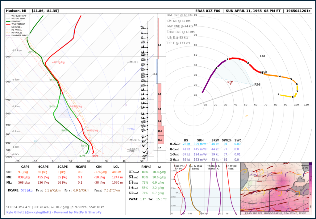
Apr 11, 1965 | Southern Mich Long Track F4 – Palm Sunday ‘Super Outbreak’
Orland, IN → Exeter Twp, MI
April 11, 1965 | 7:03 – 8:15 PM ET
F4 | 90.3mi | UND | UND
A single damaging EF-2 tornado, part of a multi-day severe weather event. The tornado was rated an F2, tracking 8.3 miles with up to 300-yard width.
Apr 11, 1965 | DeWitt F4 – Palm Sunday ‘Super Outbreak’
Dewitt → Bennington, MI
April 11, 1965 | 9:15 PM ET
F4 | 21mi | 100yd | UND
A single damaging EF-2 tornado, part of a multi-day severe weather event. The tornado was rated an F2, tracking 8.3 miles with up to 300-yard width.

Jun 26, 1969 | Traverse City F3
Traverse City, MI
June 26, 1969 | 3:30 PM ET
F3 | 6.4mi | 600yd | UND
A single damaging EF-2 tornado, part of a multi-day severe weather event. The tornado was rated an F2, tracking 8.3 miles with up to 300-yard width.

– 1970s –
Apr 03, 1974 | Hillsdale to Liberty F2 (1974 ‘Super Outbreak’)
Hillsdale → Liberty Twp, MI
April 3, 1974 | 8:44 PM ET
F2 | 19.3mi | 440yd | UND
A single damaging EF-2 tornado, part of a multi-day severe weather event. The tornado was rated an F2, tracking 8.3 miles with up to 300-yard width.

Mar 20, 1976 | Farmington Hills F4
Farmington Hills → West Bloomfield Twp, MI
March 20, 1976 | 8:15 PM ET
F4 | 3.8mi | 117yd | UND
A single damaging EF-2 tornado, part of a multi-day severe weather event. The tornado was rated an F2, tracking 8.3 miles with up to 300-yard width.

Apr 02, 1977 | Bellevue to Eaton Rapids F4
Bellevue → Eaton Rapids, MI
April 2, 1977 | 4:06 PM ET
F4 | 18mi | 616yd | UND
A single damaging EF-2 tornado, part of a multi-day severe weather event. The tornado was rated an F2, tracking 8.3 miles with up to 300-yard width.

Apr 02, 1977 | Kalamazoo to Augusta F4
Kalamazoo → Augusta, MI
April 2, 1977 | 3:30 PM ET
F4 | 12.4mi | 183yd | UND
A single damaging EF-2 tornado, part of a multi-day severe weather event. The tornado was rated an F2, tracking 8.3 miles with up to 300-yard width.

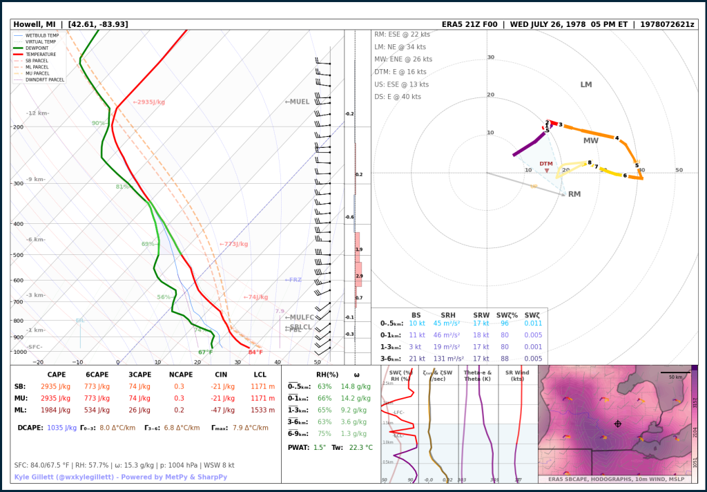
Jul 26, 1978 | Michigan Record Hail | 4.5 inches
Livingston County, MI
July 26, 1978
4.5″
A single damaging EF-2 tornado, part of a multi-day severe weather event. The tornado was rated an F2, tracking 8.3 miles with up to 300-yard width.
– 1980s –
May 13, 1980 | Infamous Downtown Kalamazoo F3
Kalamazoo, MI
May 13, 1980 | 3:58 PM ET
F3 | 10.6mi | 450ft | UND
A single damaging EF-2 tornado, part of a multi-day severe weather event. The tornado was rated an F2, tracking 8.3 miles with up to 300-yard width.

Jun 09, 1982 | Saginaw County F2
Lakefield → Saginaw, MI
June 9, 1982 | 4:25 PM ET
F2 | 19mi | 300yd | UND
A single damaging EF-2 tornado, part of a multi-day severe weather event. The tornado was rated an F2, tracking 8.3 miles with up to 300-yard width.

Jun 12, 1984 | Bay & Huron Counties (Saginaw Bay) Long Track F3
Bay City → Bay Port, MI
June 12, 1984 | 6:20 PM ET
F3 | 38mi | 500ft | UND
A single damaging EF-2 tornado, part of a multi-day severe weather event. The tornado was rated an F2, tracking 8.3 miles with up to 300-yard width.

Jul 14, 1984 | Schoolcraft & Mackinac County F2
Hiawatha → Curtis, MI
July 14, 1984 | 8:00 PM ET
F3 | 27mi | 100yd | UND
A single damaging EF-2 tornado, part of a multi-day severe weather event. The tornado was rated an F2, tracking 8.3 miles with up to 300-yard width.

Jun 10, 1987 | Upper Peninsula – Quad-County Long Track F3
Iron Mountain → Thompson, MI
June 10, 1987 | 8:05 PM ET
F3 | 71mi | 150yd | UND
A single damaging EF-2 tornado, part of a multi-day severe weather event. The tornado was rated an F2, tracking 8.3 miles with up to 300-yard width.
– 1990s –
Mar 27, 1991 | Huron National Forest Pair of F3s (Michigan’s Largest Outbreak)
Huron National Forest, MI
March 27, 1991 | 6:00 PM ET
2 F3s | 35mi | 100yd | UND
A single damaging EF-2 tornado, part of a multi-day severe weather event. The tornado was rated an F2, tracking 8.3 miles with up to 300-yard width.

Mar 27, 1991 | Michigan Record Hail | 4.5 inches
Kalamazoo County, MI
March 27, 1991
4.5″
A single damaging EF-2 tornado, part of a multi-day severe weather event. The tornado was rated an F2, tracking 8.3 miles with up to 300-yard width.

Jan 18, 1996 | Richland F0 (Michigan’s only January tornado)
Richland, MI
January 18, 1996 | 5:01 PM ET
F0 | 0.1mi | UND | UND
A single damaging EF-2 tornado, part of a multi-day severe weather event. The tornado was rated an F2, tracking 8.3 miles with up to 300-yard width.

Jun 21, 1996 | Isabella County F1
Beal City, MI
June 21, 1996 | 9:26 PM ET
F1 | 4.4mi | 80yd | UND
A single damaging EF-2 tornado, part of a multi-day severe weather event. The tornado was rated an F2, tracking 8.3 miles with up to 300-yard width.

Jun 21, 1996 | Frankenmuth F3
Frankenmuth, MI
June 21, 1996 | 11:03 PM ET
F3 | 1.1mi | 100yd | UND
A single damaging EF-2 tornado, part of a multi-day severe weather event. The tornado was rated an F2, tracking 8.3 miles with up to 300-yard width.

Jul 02, 1997 | Genesee County Pair of F3s (‘The Great Tornado Outbreak of 1997’)
Clio, MI
July 2, 1997 | 4:30 PM ET
2 F3s | 2mi | 1000yd | UND
A single damaging EF-2 tornado, part of a multi-day severe weather event. The tornado was rated an F2, tracking 8.3 miles with up to 300-yard width.

Jul 02, 1997 | Metro Detroit F2 (‘The Great Tornado Outbreak of 1997’)
Hamtramck, MI
July 2, 1997 | 6:30 PM ET
F2 | 6.7mi | 2500yd | UND
A single damaging EF-2 tornado, part of a multi-day severe weather event. The tornado was rated an F2, tracking 8.3 miles with up to 300-yard width.

Jul 23, 1999 | Mount Pleasant Brief F0
Mount Pleasant, MI
July 23, 1999 | 1:13 PM ET
F0 | 0.1mi | 10yd | UND
A single damaging EF-2 tornado, part of a multi-day severe weather event. The tornado was rated an F2, tracking 8.3 miles with up to 300-yard width.

– 2000s –
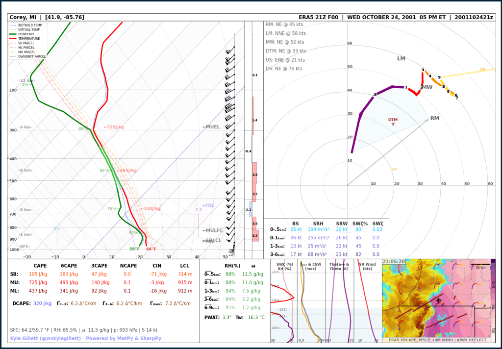
Jun 6, 2001 | Bi-State Long Track F3 (Indiana, Ohio, Michigan Outbreak)
Bertrand → Marcellus, MI
October 24, 2001 | 2:11 AM ET
F2 | 47mi | 1320yd | UND
A single damaging EF-2 tornado, part of a multi-day severe weather event. The tornado was rated an F2, tracking 8.3 miles with up to 300-yard width.
Aug 22, 2003 | Webberville F2
Webberville, MI
August 22, 2003 | 8:55 PM ET
F2 | 4.7mi | 880yd | UND
A single damaging EF-2 tornado, part of a multi-day severe weather event. The tornado was rated an F2, tracking 8.3 miles with up to 300-yard width.

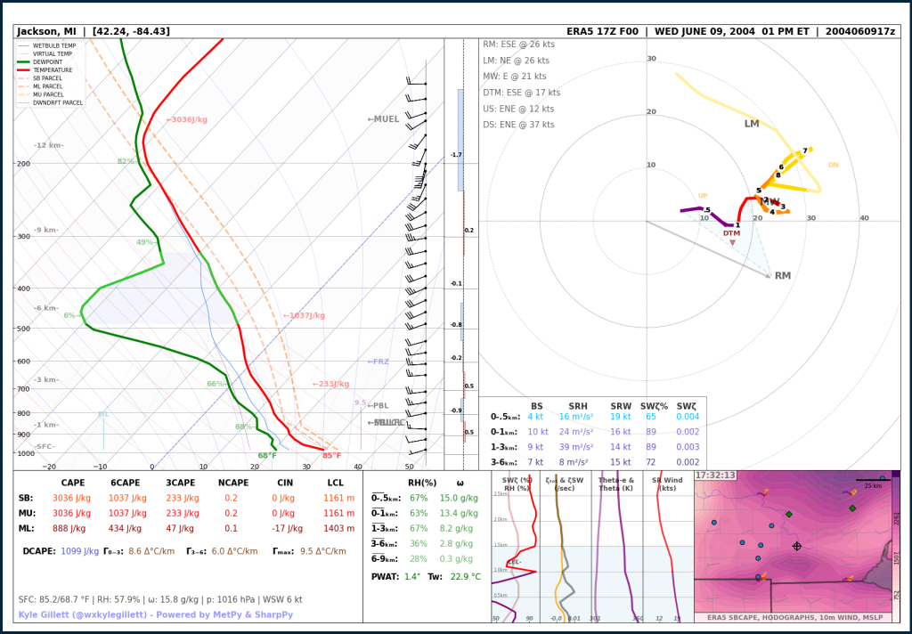
Jun 9, 2004 | Jackson County Significant Hail | 4.25 inches
Jackson County, MI
June 9, 2004
4.25″
A single damaging EF-2 tornado, part of a multi-day severe weather event. The tornado was rated an F2, tracking 8.3 miles with up to 300-yard width.
Aug 24, 2007 | Charlotte to Potterville EF3
Charlotte → Potterville, MI
August 24, 2007 | 4:25 PM ET
EF3 | 6.5mi | 300yd | UND
A single damaging EF-2 tornado, part of a multi-day severe weather event. The tornado was rated an F2, tracking 8.3 miles with up to 300-yard width.

Oct 18, 2007 | Long Rapids EF2
Long Rapids, MI
October 18, 2007 | 5:25 PM ET
EF2 | 4.1mi | 430yd | UND
A single damaging EF-2 tornado, part of a multi-day severe weather event. The tornado was rated an F2, tracking 8.3 miles with up to 300-yard width.

– 2010s –
Jun 6, 2010 | White Pigeon, Michigan EF2 (Michigan, Ohio & Indiana ‘Mini-Outbreak’)
White Pigeon, MI
June 6, 2010 | 12:32 AM ET
EF2 | 9.4mi | UND | 135 mph
A single damaging EF-2 tornado, part of a multi-day severe weather event. The tornado was rated an F2, tracking 8.3 miles with up to 300-yard width.

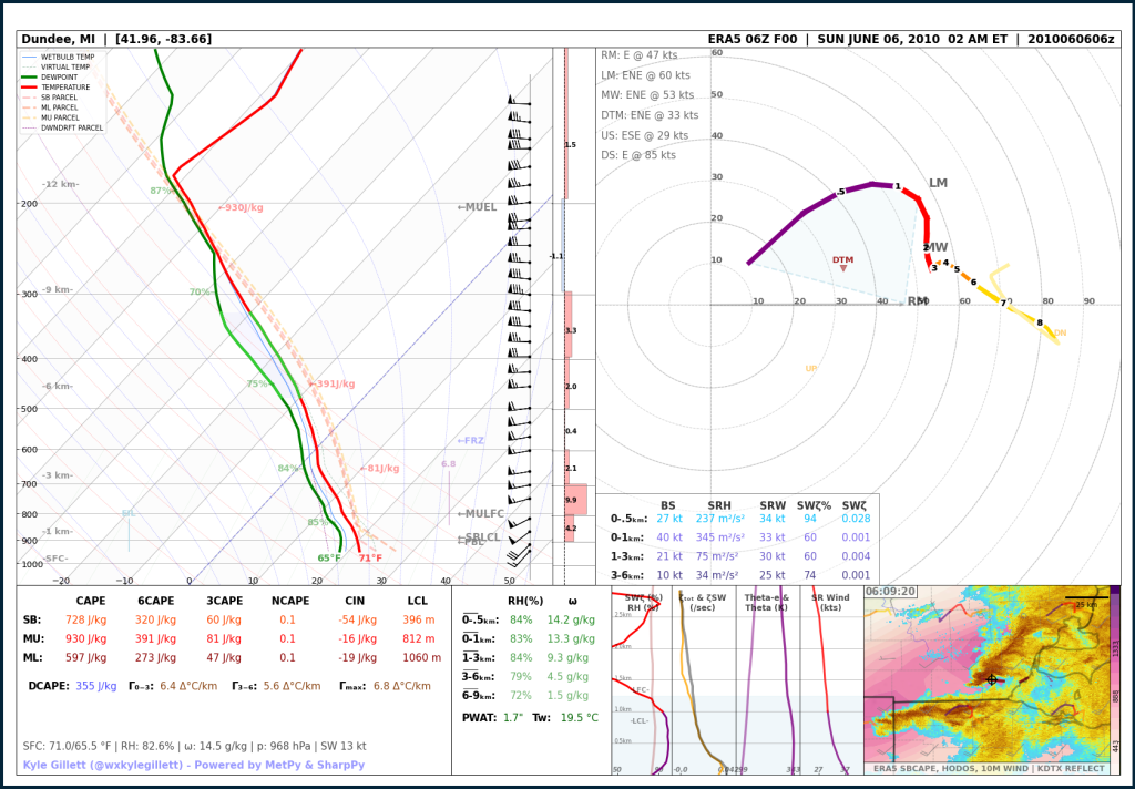
Jun 6, 2010 | Dundee, Michigan Overnight EF2 (Michigan, Ohio & Indiana ‘Mini-Outbreak’)
Dundee, MI
June 6, 2010 | 2:11 AM ET
EF2 | 13mi | 800yd | 115
A single damaging EF-2 tornado, part of a multi-day severe weather event. The tornado was rated an F2, tracking 8.3 miles with up to 300-yard width.
Apr 26, 2011 | Allegan County EF-0 (2011 ‘Super-Outbreak’)
New Salem, MI
April 26, 2011 | 5:44 PM ET
EF0 | 3.3mi | 50yd | UND
A single damaging EF-2 tornado, part of a multi-day severe weather event. The tornado was rated an F2, tracking 8.3 miles with up to 300-yard width.

Mar 15, 2012 | Dexter EF-3 (Only Violent Michigan Tornado during the 2010s)
Dexter, MI
March 15, 2012 | 5:18 PM ET
EF3 | 7.6mi | 800yd | 140 mph
A single damaging EF-2 tornado, part of a multi-day severe weather event. The tornado was rated an F2, tracking 8.3 miles with up to 300-yard width.

May 28, 2013 | Fenton, Michigan EF2 (Localized ‘Mini-Outbreak’)
Fenton → Grand Blanc, MI
May 28, 2013 | 9:30 PM ET
EF2 | 5.1mi | 500yd | 115mph
A single damaging EF-2 tornado, part of a multi-day severe weather event. The tornado was rated an F2, tracking 8.3 miles with up to 300-yard width.

May 28, 2013 | Fenton, Michigan EF2 (Localized ‘Mini-Outbreak’) | DTX Observation
Fenton → Grand Blanc, MI
May 28, 2013 | 9:30 PM ET
EF2 | 5.1mi | 500yd | 115mph
A single damaging EF-2 tornado, part of a multi-day severe weather event. The tornado was rated an F2, tracking 8.3 miles with up to 300-yard width.

Jun 22, 2015 | Birch Run EF2 – (Thumb ‘Mini-Outbreak’)
Birch Run → Millington, MI
June 22, 2015 | 9:03 PM ET
EF2 | 11.1mi | 400yd | 115mph
A single damaging EF-2 tornado, part of a multi-day severe weather event. The tornado was rated an F2, tracking 8.3 miles with up to 300-yard width.

Jun 22, 2015 | Birch Run EF2 – (Thumb ‘Mini-Outbreak’) | DTX Observation
Birch Run → Millington, MI
June 22, 2015 | 9:03 PM ET
EF2 | 11.1mi | 400yd | 115mph
A single damaging EF-2 tornado, part of a multi-day severe weather event. The tornado was rated an F2, tracking 8.3 miles with up to 300-yard width.

Aug 2, 2015 | Upper Michigan Record Hail | 4.25 inches
Ogemaw County, MI
August 2, 2015
4.25″
A single damaging EF-2 tornado, part of a multi-day severe weather event. The tornado was rated an F2, tracking 8.3 miles with up to 300-yard width.

Dec 23, 2015 | Canton EF-1 (Michigan’s Only December Tornado)
Canton, MI
December 23, 2015 | 6:43 PM ET
EF1 | 2mi | 100yd | 90mph
A single damaging EF-2 tornado, part of a multi-day severe weather event. The tornado was rated an F2, tracking 8.3 miles with up to 300-yard width.

Aug 20, 2016 | Allegan County EF1 (West Michigan QLCS ‘Mini-Outbreak’)
Allegan, MI
August 20, 2016 | 1:42 PM ET
EF1 | 12.8mi | 100yd | 110mph
A single damaging EF-2 tornado, part of a multi-day severe weather event. The tornado was rated an F2, tracking 8.3 miles with up to 300-yard width.

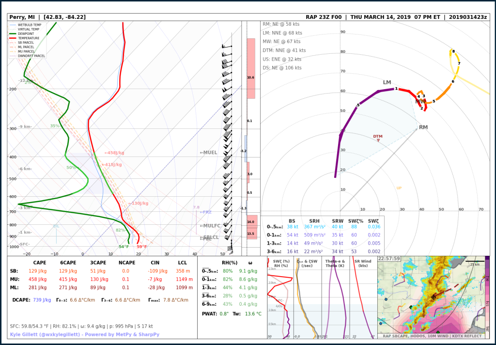
Mar 14, 2019 | Perry to Lennon EF2
Perry → Durand, MI
March 14, 2019 | 6:45 PM ET
EF2 | 18.2mi | 700yd | 125mph
A single damaging EF-2 tornado, part of a multi-day severe weather event. The tornado was rated an F2, tracking 8.3 miles with up to 300-yard width.
– 2020s –
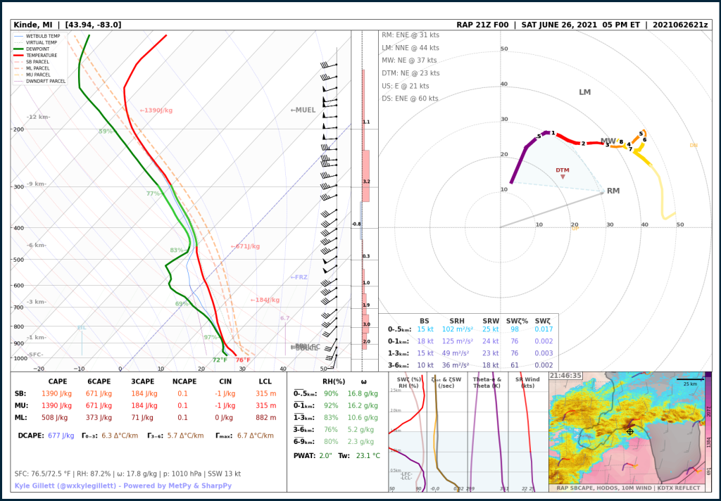
Jun 26, 2021 | Port Austin, Michigan EF2
Port Austin, MI
June 26, 2021 | 5:49 PM ET
EF2 | 6.8mi | 400yd | 120mph
A single damaging EF-2 tornado, part of a multi-day severe weather event. The tornado was rated an F2, tracking 8.3 miles with up to 300-yard width.
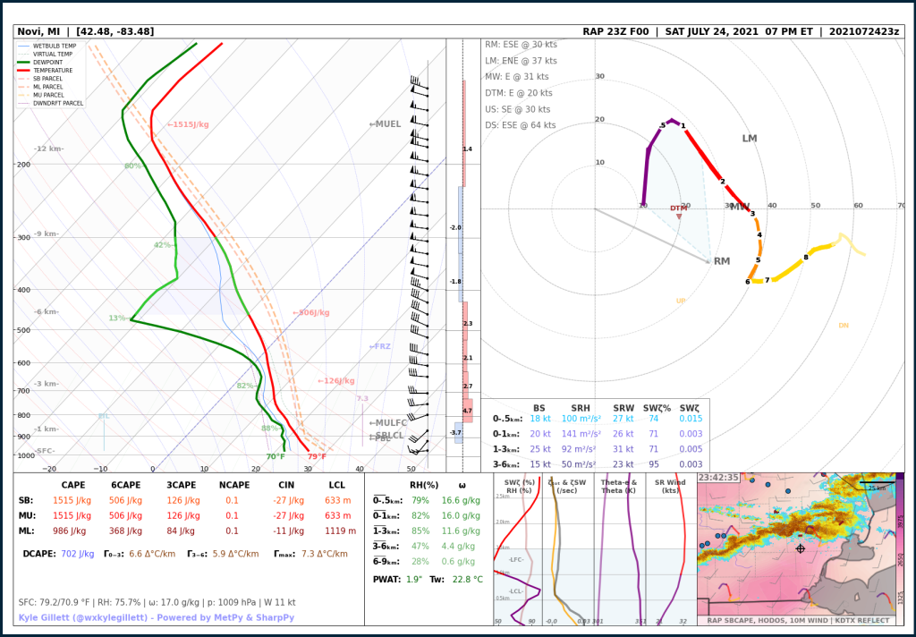
Jul 24, 2021 | White Lake, Michigan Highly Deviant EF1
White Lake Twp, MI
July 24, 2021 | 7:45 PM ET
EF1 | 1.8mi | 400yd | 100mph
A single damaging EF-2 tornado, part of a multi-day severe weather event. The tornado was rated an F2, tracking 8.3 miles with up to 300-yard width.
May 20, 2022 | Gaylord, Michigan EF3
Gaylord, MI
May 20, 2022 | 3:35 PM ET
EF3 | 17.8mi | 200yd | 150mph
A single damaging EF-2 tornado, part of a multi-day severe weather event. The tornado was rated an F2, tracking 8.3 miles with up to 300-yard width.
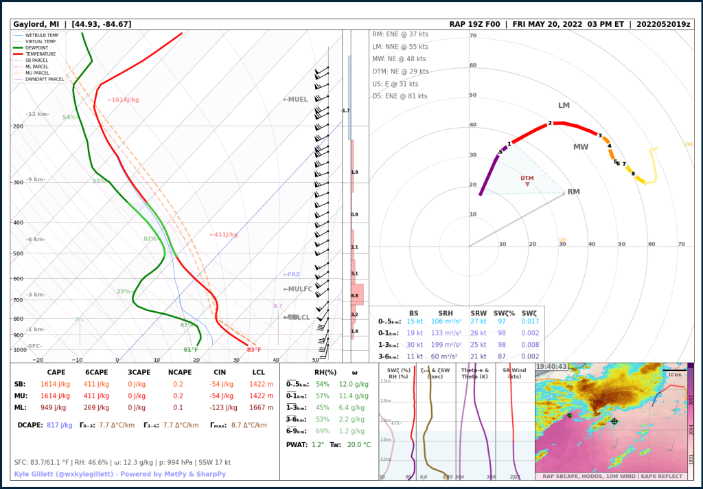
May 20, 2022 | Gaylord, Michigan EF3 | APX Observation
Gaylord, MI
May 20, 2022 | 3:35 PM ET
EF3 | 17.8mi | 200yd | 150mph
A single damaging EF-2 tornado, part of a multi-day severe weather event. The tornado was rated an F2, tracking 8.3 miles with up to 300-yard width.

Apr 1, 2023 | Dundee, Michigan Unexpected EF0
Dundee, MI
April 1, 2023 | 11:03 AM ET
EF0 | 7.3mi | 75yd | 80mph
A single damaging EF-2 tornado, part of a multi-day severe weather event. The tornado was rated an F2, tracking 8.3 miles with up to 300-yard width.

Jun 15, 2023 | Detroit Beech EF-1
Detroit Beach, MI
June 15, 2023 | 6:09 PM ET
EF1 | 4.7mi | 400yd | 90mph
A single damaging EF-2 tornado, part of a multi-day severe weather event. The tornado was rated an F2, tracking 8.3 miles with up to 300-yard width.

Jul 12, 2023 | Colon EF-1
Colon, MI
July 12, 2023 | 11:09 PM ET
EF1 | 2.9mi | 50yd | 90mph
A single damaging EF-2 tornado, part of a multi-day severe weather event. The tornado was rated an F2, tracking 8.3 miles with up to 300-yard width.

Jul 14, 2023 | Lexington Wedge EF-0
Applegate → Lexington, MI
July 14, 2023 | 3:24 PM ET
EF0 | 4.9mi | 450yd | 85mph
A single damaging EF-2 tornado, part of a multi-day severe weather event. The tornado was rated an F2, tracking 8.3 miles with up to 300-yard width.

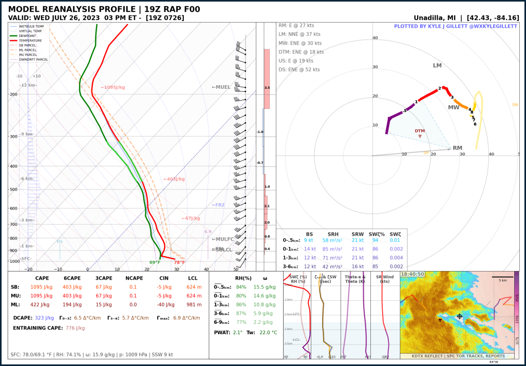
Jul 26, 2023 | Stockbridge Pair of EF-0s
Stockbridge, MI
July 26, 2023 | 2:39 PM ET
2 EF0s | 1.5mi | 150yd | 80mph
A single damaging EF-2 tornado, part of a multi-day severe weather event. The tornado was rated an F2, tracking 8.3 miles with up to 300-yard width.
Aug 11, 2023 | Downtown Perry EF-1
Perry, MI
August 11, 2023 | 8:03 PM ET
EF1 | 3mi | 430yd | 95mph
A single damaging EF-2 tornado, part of a multi-day severe weather event. The tornado was rated an F2, tracking 8.3 miles with up to 300-yard width.

Aug 24, 2023 | Alpine & Plainfield Twp. EF-1
Alpine Twp → Plainfield Twp, MI
August 24, 2023 | 8:15 PM ET
EF1 | 8.7mi | 100yd | 110mph
A single damaging EF-2 tornado, part of a multi-day severe weather event. The tornado was rated an F2, tracking 8.3 miles with up to 300-yard width.

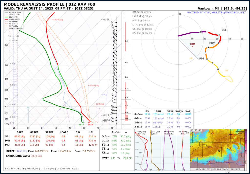
Aug 24, 2023 | Williamston-Webberville EF-2
Williamston → Webberville, MI
August 24, 2023 | 9:29 PM ET
EF2 | 12mi | 500yd | 125mph
A single damaging EF-2 tornado, part of a multi-day severe weather event. The tornado was rated an F2, tracking 8.3 miles with up to 300-yard width.
Feb 28, 2024 | Marshall Overnight EF-1
Marshall, MI
February 28, 2024 | 12:28 AM ET
EF1 | 5.5mi | 300yd | 110mph
A single damaging EF-2 tornado, part of a multi-day severe weather event. The tornado was rated an F2, tracking 8.3 miles with up to 300-yard width.

Feb 28, 2024 | Grand Blanc Overnight EF-2
Grand Blanc, MI
February 28, 2024 | 1:12 AM ET
EF2 | 5.8mi | 450yd | 115mph
A single damaging EF-2 tornado, part of a multi-day severe weather event. The tornado was rated an F2, tracking 8.3 miles with up to 300-yard width.

REANALYSIS DATA DISCLAIMER
Please note that the plots found on this page use MODELED REANALYSIS data from the RAP/RUC (2005-present), ERA-5 (1940-present) – i.e. not actual observations of the atmosphere*. Because of this, the plots provided here may not be entirely representative of the actual atmosphere that existed at the time & location of these reanalyzed plots. However, these reanalysis data provide a vertical profile that should closely resemble that of the actual atmosphere at the time. Reanalysis data are subject to the parameterization and schemes of the respective model. Plot time and location for each plot are determined by the author in order to best reflect an accurate, uncontaminated, and as-representative-as-possible profile.
*A few cases in this library are actual RAOB profiles (marked RAOB) from NWS launch sites around the time of nearby tornado events.
Note that there have been no modifications to the raw model output. Some interpolation operations take place to simplify parameter calculation and data plotting. Parameter calculations are subject to the author’s discretion.
This archive is meant to act as a library of soundings that represent notable Michigan tornado environments in order to aid CMU student forecasters in tornadic-environment pattern recognition in the state of Michigan.
Important note: vertical profiles (soundings) are not the only data forecasters should use to analyze meteorological conditions and weather phenomena. Other data sources such as surface analysis, mesoanalysis, and upper-air data should be considered but are not provided here. Check out this page for additional archive data resources.
RAP model data comes from the NOAA NCAR THREDDS data server. ERA-5 data comes from the ECMWF CDS service. Tornado stat data comes from NOAA SPC / NCEI & NOAA NWS.
The author of this page is Kyle Gillett.
Powered by SounderPy.
Acknowledgments: Cameron Nixon, Sam Brandt, Dan Butler, Ryan May. MetPy, SharpPy, Unidata.
Read more about the RAP MODEL DATA. Read more about ERA-5 MODEL DATA.
About these plots
This plot style has been developed in a way that acts to provide as much information to the user as possible with attributes designed specifically for the analysis of severe convective environments,and supercells in particular. You will also find that this particular plot style lacks many of the common and popular severe weather composite indices – that was intentional. Most, if not all, of the data provided on this plot, are considered ‘true’ observations of the atmosphere and are not related to the ideology of ‘composite-index-forecasting’ but may still be subject to heavy assumptions. The data on this plot are considered, by most, to be useful in determining critical characteristics of the atmosphere related to tornadogenesis. It should be noted that an analysis of the data presented is not provided here. This page is meant to act solely as a library of plots.

This page is currently not, and may never be entirely complete and is subject to changes at the discretion of the page author.
(C) CMU SCAMS & Kyle Gillett 2023, 2024